Results
The Homestead Act Project showed a lot of raw data on the interactive map. The data was picked through and some left out by the authors, so the data can be used as a generalization by scholars, historians, and teachers alike.
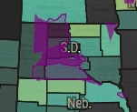
The map showed Indian Reservations throughout the Midwest and Western US get broken into smaller and smaller sections as the Homestead Act brought colonization activity into the area. Areas with the best farmland like near Wisconsin and even Kansas were among the first to be taken. Reservations located in areas with worse farmland or less useful land like New Mexico were able to hold on to larger spaces as the years went on. The Dakotas were home to another space with unusable reservation land that held itself very well despite being one of the few reservation lands open to homesteaders.